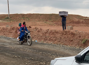


Title: ‘अकल्पनीय खाली जगह’ (An Unimaginable Empty Space), Medium: Photo installation, Photo PerformanceYear: 2021
This project is supported by Generator Co-operative Art Production Fund
The project initiated in Mundra, Gujarat, initially around the vicinity of power plants. After a year and a half, it expanded to the neighboring villages near lignite mines in the Kutch region, specifically Panandhro, Umarsar, and Mata no Madh.In the Kutch region, mining activities occurred over a span of 30 years, from 1975 to 2008, and they persist to this day. It is my belief that these activities may have contributed to the occurrence of the Bhuj Earthquake on January 26, 2001, but no one talks this as the reason. In my view, the correlation between the location, the time period, and the seismic event presents an alternative line of evidence.“The epicentre was about 9 km south-southwest of the village of Chobari in Bhachau Taluka of Kutch District of Gujarat, India. The intraplate earthquake measured 7.6 on the moment magnitude scale and occurred at 17.4 km (10.8 mi) depth. The earthquake killed between 13,805 and 20,023 people, injured another 167,000 and destroyed nearly 340,000 buildings “ wikipedia source.Panandhro and nearby mines started in 1975 till 2008. Covering an area of nine kilometres near the village of Fulra, sometimes loading upto fifteen hundred trucks a day. These days, harmful ash is being dumped to fill the void left by the extensive quarrying. One of the mining officials I encountered said to me that no local people questions or resists the mining projects even though the consequences have/had been excessive. Fulra village is barely 200 metres from the Panandhro lignite mining border. Due to the required expansion of the mining grounds, the geography was changed and the villages were dislocated. In the process, the course of the Godavari river was redirected and the village of Umarsar had to be completely evacuated and displaced. Unlike Panandhro, Umarsar and Mata no Madh still have an active mine surrounding villages that harbour a small population.
In this body of work, I have used images to put up photo installations and video performances in the space between the mines and the periphery of the villages. Initially, the images of the work were put around the boxes and taken around mining area, Afterwards, the photographs were put up on the fences of the mining grounds, some distance away from the locality. It was to observe the outcomes of putting forth certain images at different locations and how they might trigger changes in the perception of the viewer. It was also to produce an affect by overlapping images with the space, and observe what subjectivities they can produce while questioning the extraction that has amounted to an irreparable scar.
